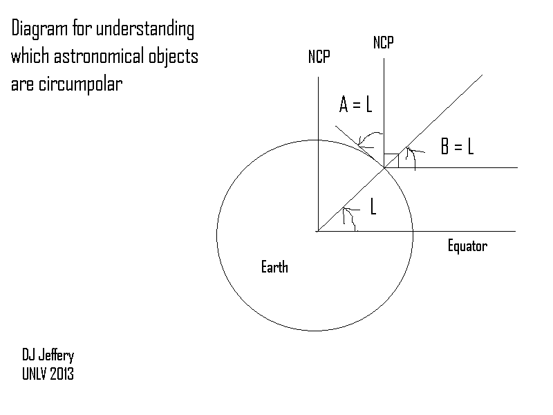
Caption: A diagram giving---for the cognoscenti---a proof by inspection that the altitude above due north of the north celestial pole (NCP) A_N_NCP equals the observer's latitude on Earth L: i.e.,
A_N_NCP = L ,
where L for south latitude is counted as negative number.Note that a right angle can be rotated into a right angle.
Features:
- Latitude:
L = δ ± [A(±) - 90°]: For finding latitude with south latitude counted as a negative number. This formula is used in celestial navigation.
L = δ + [A_N - 90°] L = δ - [A_S - 90°]
- Longitude (λ):
λ = (360°/P)(t_UT - t_UT_G) where: P is the period: sidereal day for fixed stars, apparent solar day for the Sun. t_UT is the marine chronometer time of the transit of meridian. t_UT_G is the prime meridian (Greenwich meridian) time of the transit of meridian which you read from some source (e.g., a nautical almanac) but is about your local time as appropriate for the astronomical objects???. - Complications:
- weather.
- achieving accurate/precise time of the transit.
- atmospheric refraction.
- The circumpolar sky:
Now we see that the general
formulae for both
hemispheres are
δ ≥ δ_N_circ = 90° - |L| and δ ≤ δ_S_circ = - δ_N_circ = |L| - 90° .
At the equator (L=0), there is NO circumpolar sky. At the poles (L=±90°) all the sky is circumpolar sky. - Celestial navigation
keywords:
accuracy/precision,
altitude,
analemma,
astrolabe,
atmospheric refraction.
astronomical object,
celestial navigation,
culmination (AKA transiting the meridian),
declination (Dec or δ),
dead reckoning,
ephemerides,
equation of time,
equatorial coordinate system
(right ascension (RA),
declination (Dec or δ)),
fixed stars,
Galilean moons of Jupiter,
Galileo (1564--1642),
geographical coordinate system
(latitude,
longitude),
H4 marine chronometer,
horizon,
horizontal coordinate system,
John Harrison (1693--1776),
latitude,
longitude,
lunar phases,
marine chronometer
(H4 marine chronometer),
meridian (AKA celestial meridian),
Moon,
nautical almanac,
navigation,
noon
(solar noon),
prime meridian (Greenwich meridian),
right ascension (RA),
sextant,
sky map (AKA star chart),
sidereal time,
solar noon,
solar time
(apparent solar time,
mean solar time),
Sun,
transit,
Universal Time (UT)
(Greenwich Mean Time
which is NOT quite the same thing),
weather,
etc.
-
Navigation videos
(AKA Navigation
videos):
- SLOW TV - Beating Upwind to Grenada - Sailing Vessel Delos | 39:40: In slow TV nothing happens.
- SUHAILI ON THE SOLENT | 0:41: "Suhaili, the legendary boat on which Sir Robin Knox-Johnston (1939--) became the first man to sail around the world singlehanded and non-stop. (a non-stop, solo sailing circumnavigation). Seen here sailing for the first time after her restoration at the Hamble-le-Rice Classics Regatta in 2016 September, with Sir Robin's daughter Sara at the helm." (Slightly edited.)
- Roger Whitttaker --- The Last Farewell | 4:08: Roger Whittaker (1936--). The song The Last Farewell is based on a modern amateur poem. Alan Rickman (1946--2016) seems to be in the video, but I can't identify the flick.
- "The Wreck of the Edmund Fitzgerald" - Gordon Lightfoot | 6:39:
Image link: Itself.
Local file: local link: navigation_celestial.html.
File: Celestial sphere file: navigation_celestial.html.