 A space shuttle pre-dawn with Venus and Mars. Discovery, 1995aug03.
Venus is the brighter star. If you see Mars near the Sun in angle, it must beyond the Sun in space and therefore will be relatively dim compared to Venus.
The shapes are not significant I think: some artifact of the imaging process.
Venus is the Morning and the Evening Star. I've only seen it as the Morning Star in 1994 when I tramped across the Englischer Garten in Munich at 6:00 am or so.
As the Morning Star it is called the Son of Morning in the Bible, or Bringer of Light: i.e., Lucifer.
Credit: NASA.
 ``Ultraviolet image of Venus'
clouds as seen by the Pioneer Venus Orbiter (Feb. 5, 1979).''
``Ultraviolet image of Venus'
clouds as seen by the Pioneer Venus Orbiter (Feb. 5, 1979).''
This is false color, of course. The pattern is not at all as distinct in the visible.
The clouds are at 50--70 km in altitude and are moving west at speeds of up to of order 300 km/hr The whole atmosphere seems to rotate with a period of about 4 days.
The pattern is of two vortices that split at the equator and spiral to the pole.
The Y pattern of the clouds is clearly seen.
Credit: NASA.
 Five hemisphere views from Magellan radar maps.
Lava flows and faults appear as bright in the image.
Radar mapping is sensitive to the roughness of terrain and relatively younger lava is rougher than older material. This is how lava flows have been distinguished (Se-470).
Map a is centered on the north pole. Maxwell Montes is the bright region near the center: it is the highest mountain range on Venus.
The other maps are centered on the equator.
Map b at 0 longtitude.
Map c at 90 longtitude.
Map c at 180 longtitude.
Map d at 270 longtitude.
The color is false, of course, but was chosen to emphasize structural detail and simulate the colors seen on the surface by the Soviet Venera landers.
The scattered dark patches are halos surrounding the youngest impact craters. A study of the impact craters shows that Venus' surface is probably 500 to 800 Myr old (HI-177). (The time scales vary with reference source.)
Credit: NASA. See NASA Caption.
 Venus disrobed.
This is Map d from nasa_venus_003_topography.jpg
Credit: NASA; download site: ????.
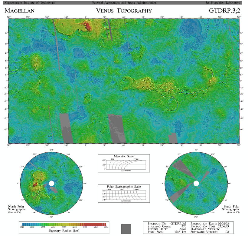 Venus Mercator topographical map based on Magellan radar mapping.
The extended high region near the north pole is Ishtar Terra (about the size of Australia) of and the one near the equator is Aphrodite Terra (about the size of Africa). A lower altitude Lada Terra is near the south pole.
The terras are the continents of Venus and they rise above the lowland lava plains which are analogous to the oceanic basins of Earth (Se-471???).
About 60 % of Venus is lowlands and 40 % uplands: the uplands are 24 % terras and 16 % are huge volcanic peak regions (HI-174--175). The terras are less extensive than Earth's continents that cover 41 % of the Earth (Cox-253).
Most of the rock found by the Soviet Venera Landers was basaltic (i.e., fast cooled lava that becomes dark iron and magnesium rich rock). This rock is similar to oceanic basalt and presumably was found on the Venusian lowlands.
One of the Soviet Venera Landers found granitic rock which is what Earth continents are dominated by (HI-175). But was it found on a terra????.
Maxwell Montes is the red region on Ishtar Terra. It is the highest mountain range on Venus.
Maxwell Montes rises about 11 km above the lowland plains. It was named for James Clerk Maxwell and is the only feature named for a male on Venus. Maxwell's theory of electromagnetism led to radar (after a 70 years) and so was fittingly honored on a radar map (Se-191).
The statistics: 60 %rolling plains; 24 % highlands, 16 % very high volcanic peaks (Se-190,191).
Credit: NASA; download site: Views of the Solar System by Calvin J. Hamilton. This image public domain, but CJH declines to give a download source.
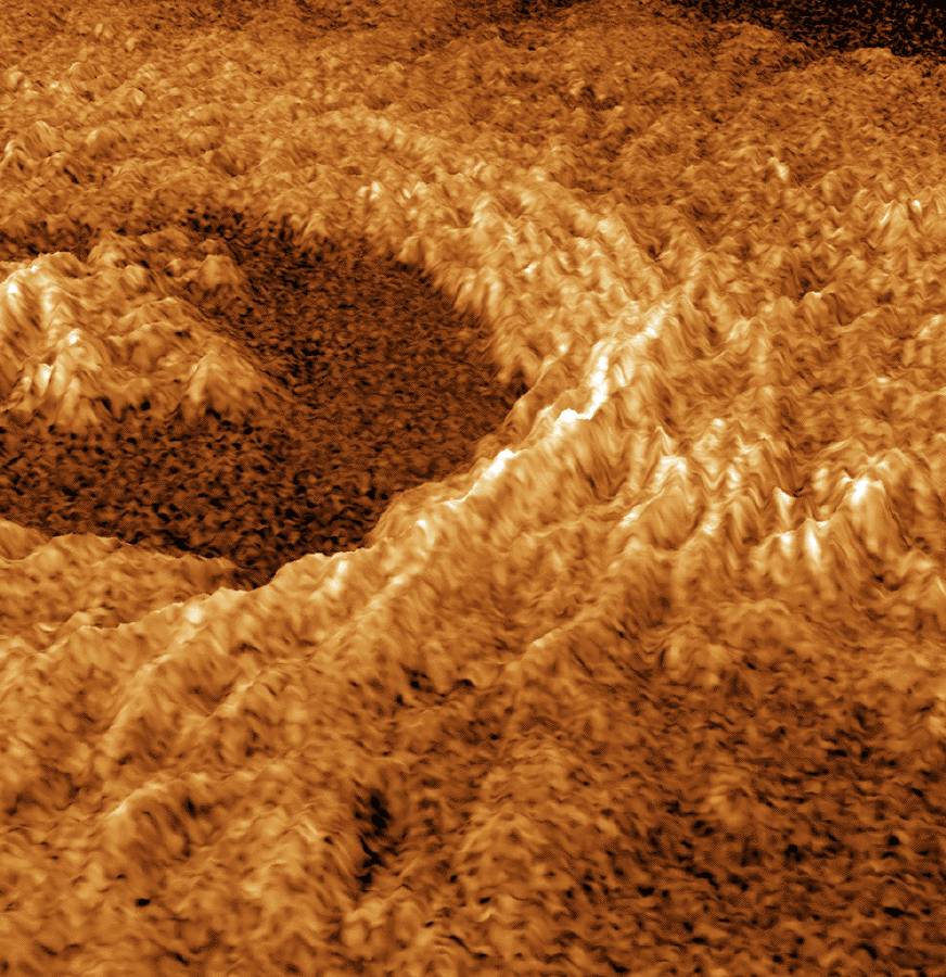 A 3-d model of Venus impact crater Golubkina based Magellan radar mapping.
The color is false, of course, but was chosen to emphasize structural detail and simulate the colors seen on the surface by the Soviet Venera landers.
The vertical scale may be stretched to emphasize the features.
This seems to be a typical impact crater with central peak, flatish floor, and slumping rim walls.
Credit: NASA; download site: Views of the Solar System by Calvin J. Hamilton. This image is public domain, but CJH declines to give a download source.
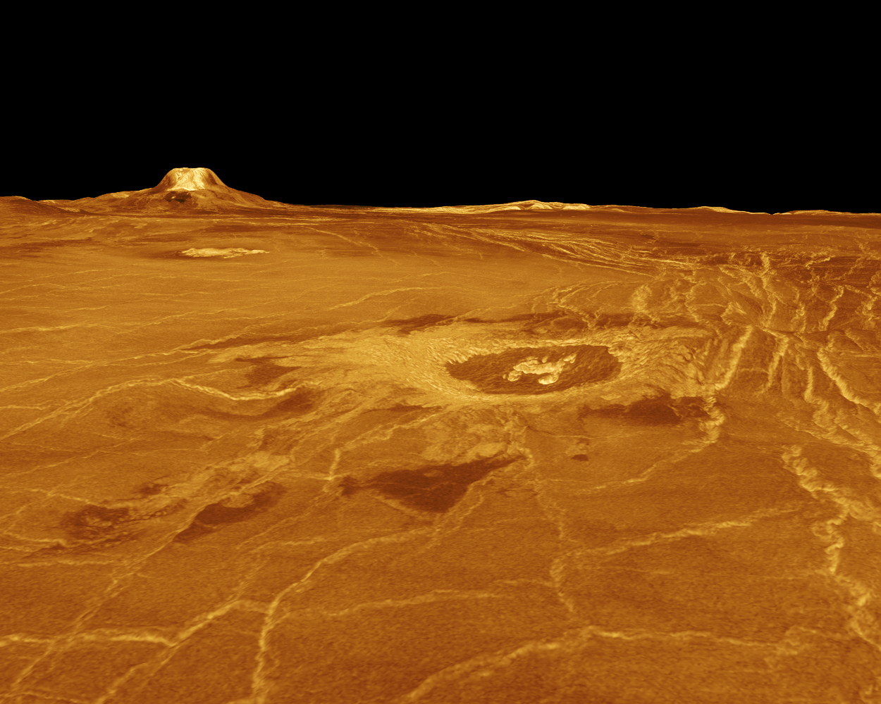 A model 3-d view of Gula Mons and Crater Cunitz on the western
part of Eistla Regio.
A model 3-d view of Gula Mons and Crater Cunitz on the western
part of Eistla Regio.
Lava flows and faults appear as bright in the image.
Eistla Regio is about at the west end of Aphrodite Terra and south of the east end of southmost reaching part of Ishtar Terra.
-
[Eistla is a Norse giantess.
A regio is a large area marked by
reflectivity or color distinctions from adjacent areas,
or a broad geographic region.]
The image is based on radar data from the Magellan orbiter The colors are meant to imitate those shown by the Soviet Venera 13 and 14 landers and are used to enhance surface structure.
The elevations have been stretched by a factor 22.5 ??? to enhance visualization ( NASA NSSDC Photo Gallery Venus)..
You are looking from an elevation of 0.78 km to the north-east toward Gula Mons which is 1,310 kilometers away.
Gula Mons is a 3 km high volcano: it is a normal shield volcano (Se-473), but the stretching has made it look a bit unnatural???. The height is relative to the Eistla Regio ( NASA NSSDC Photo Gallery Venus).
Gula is a Babylonian earth mother: symbolically a creative force---I just quote the sources.
Impact Crater Cunits is named for Polish mathematician and astronomer Maria Cunitz (1610--1664). It is in the foreground and 215 km from the observer. The crater diameter 48.5 km. It shows the rim and flatish inner floor with a central peak of a typical large impactor crater.
JPL Multimission Image Processing Laboratory produced the image for release at a 1991mar05 JPL news conference.
Credit: NASA/JPL; download site: Views of the Solar System by Calvin J. Hamilton. The images are public domain, but CJH declines to give a download source.
 Boann Corona on Venus with multidinous shield volcanoes from Magellan
radar mapping.
Boann Corona on Venus with multidinous shield volcanoes from Magellan
radar mapping.
There are also about 360 roughly circular domes or depressions called CORONAS surrounded by circular and radial fractures and located with some volcanos (HI-176).
Some are flooded by lava.
These features are typically 200 to 400 km in diameter. They may also represent extreme hotspot volcanism where there is a rising mantle plume of magma.
Upwelling lava would create dome which later can subside to create a depression.
Coronas are NOT found on any other solar system body.
Boann is about 225 km across on its shortest side. There are multidinous small shield volcanoes on Boann lava-flooded center. Credit: NASA.
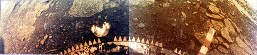 A Venera 13 lander image of the Venus surface. 1982mar01.
The Venera 13 survived only 2 hr, 7 minutes in the hot, high pressure conditions on Venus. Part of the lander and a camera lens are at the bottom of the picture. Flat rocks and soil are visible. The rock seems to be similar to terrestrial basalt (i.e., dark, denser silicates rich in magnesium and iron probably formed from rapid cooling of lava probably on the surface).
This is a color image, but Venusian atmosphere filters out blue light. What you would see without the atmosphere is a bit uncertain.
Credit: Soviet space agency; download site NASA.
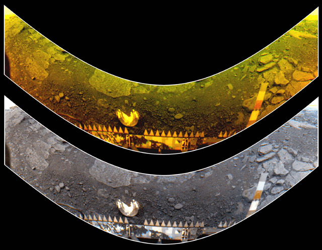 A Venera 13 lander image of the Venus surface. 1982mar01.
The Venera 13 survived only 2 hr, 7 minutes in the hot, high pressure conditions on Venus.
Part of the lander and a camera lens are at the bottom of the picture.
Flat rocks and soil are visible.
The rock seems to be similar to terrestrial basalt (i.e., dark, denser silicates rich in magnesium and iron probably formed from rapid cooling of lava probably on the surface).
The top image is true color to the Venusian atmosphere where blue light is filtered out. The bottom image is an attempt to correct the image to Earth lighting.
The lander's colored bar (seen in the image) had a known color scheme and that allowed the correction to Earth lighting.
Credit: Soviet space agency; download site Views of the Solar System by Calvin J. Hamilton. The images are public domain, but CJH declines to give a download source.