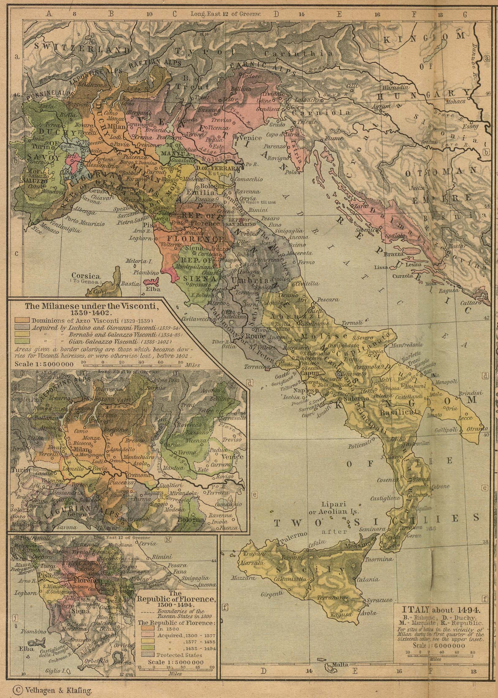
 Caption:
Italy
circa 1494.
-
Other Italy maps:
Italy 1921: with some physical features,
Italy 1796:
north from Florence with some physical features,
Italy: physical map,
Italy and more: physical map.
The year 1494 is too early for Galileo (1564--1642), but things hadn't changed too much by his time.
However, the Florence Republic had been transformed into the Grand Duchy of Tuscany. Galileo seems to have been happy as a Grand Ducal servant instead of a free Florentine.
As far as yours truly can figure out, Galileo was pretty much a homebody and NEVER went out of the Pisa-Venice-Rome triangle. He may have lived in the Age of Exploration (c.1400--c.1800), but he may NEVER have sailed, except on a gondola.
Selected locations with associated favorite persons of Medieval Italy and Renaissance Italy (see also Wikipedia: Renaissance) and even earlier and later:
- Assisi: St. Francis of Assisi (1181/1182--1226).
- Elba: Napoleon (1769--1821).
- Florence / Florence (historical) / Florence Republic: Amerigo Vespucci (1454--1512), Coluccio Salutati (1331--1406), Dante Alighieri (1265--1321), Donatello (c.1386--1466, Donato di Niccolo di Betto Bardi), Fra Angelico (1395?--1455), Francesco Guicciardini (1483--1540), Filippo_Brunelleschi (1377--1446), Galileo Galilei (1564--1642), Giorgio Vasari (1511--1574), Giovanni dalle Bande Nere (1498--1526), Giotto (1266/7--1337), Leonardo da Vinci (1452--1519), Lorenzo de' Medici, Lorenzo Ghiberti (1378--1455), Maria Celeste (1600--1634, AKA Virginia Galilei), Mathilda of Tuscany (c.1046--1115, reigned 1055--1115 as Countess), Michelangelo (1475--1564), Niccolo Machiavelli (1469--1527), Petrarch (1304--1374, AKA Francesco Petrarca), Sandro Botticelli (1445?--1510), Simonetta Vespucci (1453--1476). See maps: Florence 1913, Florence 1943/4, Florence: historic sites, Florence: central, Florence: Its Historic Buildings and Famous Streets (good: google: Florence map its historic buildings and famous streets britannica), Florence: Historic Buildings (not bad: google: map historic buildings), etc.
- Monte Cristo: Dragut (1485--1565), Count of Monte Cristo (c.1790--after c.1840), Mamilian of Palermo (4th century). Maps: Monte Cristo: hand drawn, Monte Cristo: sites, physical features, Monte Cristo: tourist map, Tuscan Archipelago.
- Parma: Alexander Farnese, Duke of Parma (1545--1592).
- Pavia: Gerolamo Cardano (1501--1576, AKA Jerome Cardan).
- Pienza: Pius II (1405--1464, pope 1458--1464, AKA Enea Silvio Bartolomeo Piccolomini, AKA Aeneas Silvius Bartholomeus) (his hometown and patronage object).
- Pisa: Fibonacci (1170?--1250?, AKA Leonardo Bonacci, Leonardo of Pisa), Vincenzo Galilei (1520?--1591).
- Rome / Rome (historical): Artemisia Gentileschi (1593--after 1654), Evangelista Torricelli (1608--1647), Giordano Bruno (1548--1600), Julius II (1443--1513, pope 1503--1513, AKA Giuliano della Rovere), Lucrezia Borgia (1480--1519), Pius II (1405--1464, pope 1458--1464, AKA Enea Silvio Bartolomeo Piccolomini, AKA Aeneas Silvius Bartholomeus), Raphael (1483--1520), Vittoria Colonna (1492--1547) (a granddaughter of Federigo da Montefeltro (1422--1482)). Maps: Rome: Middle Ages to 17th century.
- Siena: Il Sodoma (1477--1549).
- Urbino: Bramante (1444-1514) (his hometown), Baldassare Castiglione (1478--1529), Federigo da Montefeltro (1422--1482), Piero della Francesca (c.1415--1492), Raphael (1483--1520) (his hometown). See maps: Urbino 1689: poorish, Urbino: tourist good, Subprefecture of Urbino: schematic, but not bad, Marche: physical map: good, Marche: physical map: good.
- Venice / Venice Republic: Aldus Manutius (1449--1515), Andrea Palladio (1508--1580), Marina Gamba (1570?--1612?), Nicolaus Copernicus (1473--1543) (for some of his education in Italy), Paolo Sarpi (1552--1623), Pietro Aretino (1492--1556), Veronica Franco (1546--1591). See maps: Venetian territories as of 1797 (1819), Venetian Italian territories as of 1779 (1819), Venetian Lagoon, Venetian Lagoon central region, Venetian Lagoon central region 2, Venice 19th century, Venice 1913, Venice 1933 Venice main sights, Venice main sights 2, Venice main sights 3, Venice main sights 4, Venice, Grand Canal, Venice east, Venice west.
Credit/Permission:
Willliam R. Shepherd (1871--1934),
Historical Atlas (1923,1926) /
Public domain.
Image links in order of increasing directness:
(1) Perry-Castaneda Library Map Collection,
(2) Perry-Castaneda Library Map Collection: Historical Maps,
(3)
Historical Atlas (1923,1926),
William R. Shepherd (1871--1934),
(4)
Italy about 1494 (774K) [p.90] [1923 ed.]:
scroll down ∼ 40% in "(3)".
Local file: local link: map_italy_1494.html.
File: Maps file:
map_italy_1494.html.