Caption: Thomas Digges's (1546--1595) illustration (presented in his treatise A Perfit Description of the Caelestiall Orbes according to the most aunciente doctrine of the Pythagoreans, latelye revived by Copernicus and by Geometricall Demonstrations approved, 1576) of a heliocentric solar system surrounding by an infinite space with stars spread throughout.
Infinite universes had been considered before, of course, but Digges to consider an infinite universe in the context of a heliocentric solar system.
Since the caption is in Elizabethan English, we can even read it sort of.
Isaac Newton (1643--1727) thought of the spread out stars as being the fixed stars which defined the fundamental inertial frame.
The colorization is modern.
Credit/Permission: Thomas Digges (1546--1595), 1576, Colorized by Jean Gagnon (AKA User:Jeangagnon), 2007 / Public domain.
Image linked to Wikipedia.
Therefore, we an project all of them as viewed from the point-like Earth onto infinitely remote imaginary sphere which we call the celestial sphere.
A globular map of the the celestial sphere is a celestial globe
Astronomical objects on the celestial sphere can be located using equatorial coordinates.
The animation below illustrates equatorial coordinates.
Caption: An animation illustrating the celestial sphere, equatorial coordinates, right ascension (RA), declination (dec), north celestial pole (NCP), south celestial pole (SCP), the celestial equator, the vernal equinox, and the ecliptic.
The equatorial coordinate system is essentially a projection (as viewed from the center of the Earth) of the geographic coordinate system onto the celestial sphere.
The equatorial coordinate system is tied to location and axial rotation of Earth.
This is parochial---but the Earth is our parish---our observing platform for the observable universe.
The equatorial coordinate system reflects the practicalities of observing from Earth.
For example, the altitude from due north of an astronomical object transiting the meridian is given by the following simple formula:
Alt=90+Lat-δ , where Lat is latitude (counted as negative if south latitude) and δ is declination.
Such a simple formula is not possible for other choices for an angular coordinate system for the celestial sphere.
Credit/Permission: © User:Tfr000 / Creative Commons CC BY-SA 3.0.
Image linked to Wikipedia.
Everything on the sky can be located in equatorial coordinates.
Extra-solar-system astro-bodies have approximatlely fixed equatorial coordinates at least over human lifetimes. There is slow variation due to axial precession (see below).
Everyone find and touch celestial equator, NCP, SCP, and the vernal equinox.
The celestial equator is a great circle---which is a circle that divides a sphere in half.
The RA meridians are also great circles.
What is the vernal equinox?
The zero point of RA celestial globe as 0 RA or as the vernal equinox or as the point where the ecliptic crosses the celestial equator going north.
In the inertial frame of the fixed stars, the Earth orbits the Sun.
But in the non-inertial frame non-rotating geocentric frame of the Earth, The Sun orbits the Earth against the backgound of the celestial sphere on which all the extra-solar-system astro-bodies are approximately fixed.
The ecliptic is the great circle path of the Sun on the celestial sphere.
The Sun moves eastward and takes a year to complete an orbit.
The vernal equinox is the point where the ecliptic crosses the celestial equator going north.
When the Sun is at that point, it is the begining of spring---this point in time is also called the vernal equinox---vernal equinox has two meanings.
Caption: A whole-sky sky map displaying the equatorial coordinate system, ecliptic, the constellations and the Milky Way.
Credit/Permission: © User:Tfr000, 2012 / Creative Commons CC BY-SA 3.0.
Image linked to Wikipedia.
Well the plane of the Earth's orbit---which is also the Sun's orbit around the Earth---is the ecliptic plane.
The ecliptic plane cuts the celestial sphere at the ecliptic.
The ecliptic pole is perpendicular to the ecliptic plane.
The Earth's axis is tilted from the ecliptic pole by about 23.4 degrees---everyone knows the tilt, but few know what the tilt is respect to---it's to the ecliptic pole.
Since the Earth's axis is titled from the ecliptic pole by 23.4 degrees, the Earth's equator and the celestial equator are tilted from the ecliptic by 23.4 degrees.
The animation illuatrates the tilt of the ecliptic from the celestial equator.
Caption: "An animation illustrating the equatorial coordinates, ecliptic coordinates, and Galactic coordinates on the celestial sphere. Each set of coordinates is displayed for a about 10 seconds." (Slightly edited.)
The equatorial coordinates are the main coordinates for astronomy.
Credit/Permission: © User:Tfr000, 2012 / Creative Commons CC BY-SA 3.0.
Image linked to Wikipedia.
This is much of the problem in understanding the sky.
The ground to us is an infinite plane that cuts the celestial sphere in half---half, below and half above.
Here we idealize the the ground as a plane that is exactly perpendicular to the vertical line to the Earth and that plane is tangent to the actual ground.
As the Earth rotates around on its Earth's axis, the half we see keeps changing continuously---daylight and clouds also impede our view of the sky.
The horizon is the great circle dividing sky in two.
We see above not below it.
The term horizon is also used for the dividing plane itself.
With the proper instuments, equatorial coordinates are easy to use.
But for just casual observation and telling people where something is when they are right there beside, equatorial coordinates are not so great---``where the heck is that RA and dec?"
Caption: The horizontal coordinate system illustrated.
The horizontal coordinate system has its origin is wherever you are on the surface of the Earth.
In the system, one locates an object using altitude (the angle from the horizon along a great circle through the zenith) and azimuth (an angle along the horizon measured east from due north).
It is in the horizontal coordinate system that zenith and nadir arise.
Zenith is the point on the sky directly above the observation point. It's on the vertical from the observer.
Nadir is the opposite point on the sky which you usually can't see since you-know-what is in the way.
Credit/Permission: © User:TWCarlson / Creative Commons CC BY-SA 3.0.
Image linked to Wikipedia.
But a given set of Horizontal coordinates only locate an astro-body for one moment in time at one location.
So they are no good for catalogs of location.
Atitude can be approximately measured easily: a spread hand at arm's length subtends about 18 degrees.
Find Polaris and right down along its altitude line is due north.
The event of transiting is called a transit.
What decides?
First, to be simple, let's just consider a Northern Hemisphere case: the Southern Hemisphere is sort of the mirror image case.
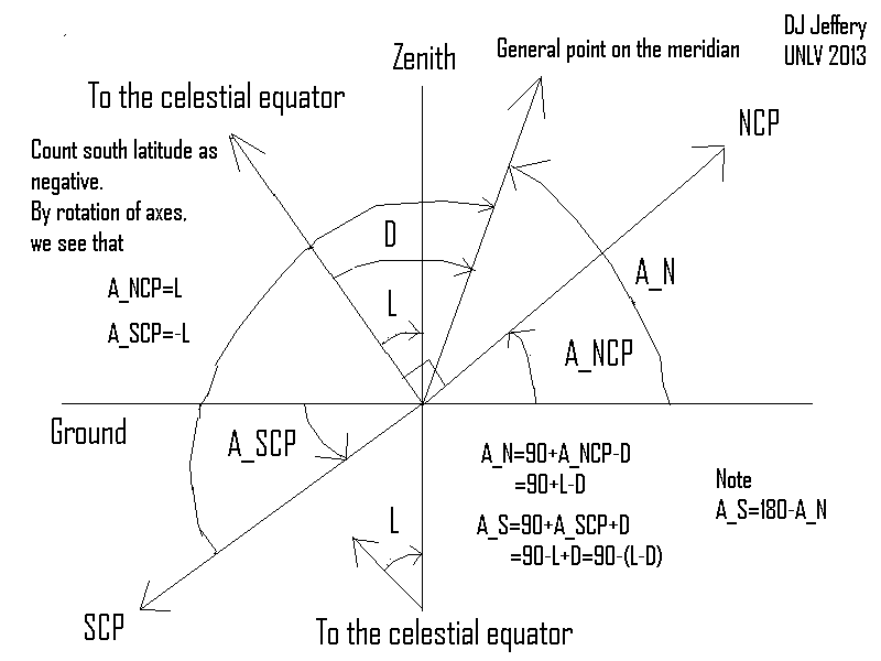
Next note that NCP is one thing on the sky with a fixed altitude with respect to time (but not location on Earth) since it does NOT rotate with the celestial sphere.
A little geometry shows that NCP's altitude is equal to the latitude of the observation location.
NCP altitude and latitude.
Caption: The conversion of declination to altitude for an object transiting the meridian.
The diagram derives the conversion formula.
If a small circle is too nearer the NCP than the NCP's altitude, then small circle never falls below the horizon and its astro-body is always above the horizon.
If a small circle is too nearer the SCP than an angle equal to the NCP's altitude, then small circle never rises above the horizon and its astro-body is always below the horizon.
Astro-bodies that never rise or set are called circumpolar objects: they could be circumpolar stars circumpolar constellations.
Caption: Circumpolar stars rotating around the NCP. One can see the Big Dipper (with lines), the Little Dipper (without lines), and Cassiopeia (the big W with lines).
One can see rotation like this from a sufficiently northern latitude in the Northern Hemisphere.
Of course, daylight makes it hard to see a complete rotation.
The off-an-on yellow lights seem to be highlighting certain constellations: Cepheus (just counterclockwise of Cassiopeia), Draco (just counterclockwise of Cepheus), and the Little Dipper.
The other yellow lights seem to be in windows of buildings in a cityscape.
Credit/Permission: © User:Mjchael / Creative Commons CC BY-SA 2.5.
Image linked to Wikipedia.
So any astro-body closer to the NCP than an angle equal to the local latitude is circumpolar and never sets.
And any astro-body closer to the SCP than an angle equal to the local latitude is circumpolar and never rises.
All other astro-bodes are NOT circumpolar and rise and set every day on the horizon.
These non-circumpolar astro-bodes follow arcs on the sky which are the visible part of their small circle paths.
Extra-solar-system astro-bodes always rise and set at the same azimuths (which are equal in magnitude and opposite in sign) at least approximately over the course of a human lifetime.
Solar-system astro-bodes move continuously on the celestial sphere and this is noticeable over very short time periods.
Well everyday it circles west on a small circle. So it follows an arc on the sky when above the horizon.
But it also moves relative the celestial sphere thought of as attached to the fixed stars on eastward the ecliptic.
It takes one year (approximately 365.25 days) to complete it's path on the ecliptic.
So it moves at about 1 degree per day---the ancient Babylonians may have chosen to divide the circle into 360 degrees to get this angular velocity.
This means the small circle path of the Sun varies north and south of the celestial equator by the Earth's axial tilt of 23.4 degrees.
The maximum declination is called the summer solstice.
Minimum is called the winter solstice.
When the Sun is on the celestial equator, it is called an equinox: when the Sun is going north it is the vernal equinox and when it is going south is the fall equinox.
The solstices and equinox happen about 91 days apart.
Fiducial dates are Mar21 vernal equinox, Jun21 summer solstice, Sep21 fall equinox, and Dec21 winter solstice.
The actual dates of the solstices and equinoxes vary a bit for several reasons.
The main one is that the solar year (vernal equinox to vernal equinox) is NOT a whole number of days: it is about 365.242 days---it varies a bit due all kinds of things.
But calendar years have whole numbers of days.
We fixed things up to keep solar year count and calendar year count synchronized over long periods of time by alternating the length of the calendar year between 365 days (ordinary years) or 366 days (leap years) in a way prescribed by the Gregorian calendar.
Because of the short-term desynchronization of the solar year count and calendar year count the solstices and equinoxes can move a calendar day or so off the fiducial dates.
The Solstices and equinoxes mark the beginnings of the astronomical seasons that their names indicate.
Because the Sun moves continuously eastward relative to the fixed stars, one can also say that the fixed stars move continuously westward relative to the Sun
This means that the solar times for fixed stars happen earlier every day: rises times, setting times, and transit times.
For example, say a particular star transits the meridian at the same time as the Sun (i.e., at solar noon) on a given day.
This means the star and Sun are at the same RA.
Next day, the star has moved westward from the Sun and will transit the meridian before solar noon.
Of course, earlier and earlier times eventually cycle back to the times where they started.
If a star rises with the Sun on a given day (called its heliacal rising), then it will rise earlier and earlier until a year later is it is rising with the Sun again.
Which constellations the Sun and ecliptic passes through depends on how you define constellation and how you define passing through a constellation.
But in traditional astrology, their are 12 constellations on the ecliptic which are called the zodiac constellations: Aries, Taurus, etc.
On average, it takes about 30 days for the Sun to move through a zodiac constellation.
Caption: The Earth orbiting the Sun with the zodiac constellations displayed.
The red circle is the ecliptic. The zodiac constellations straddle the ecliptic.
The blue circle is the celestial equator.
When the Sun is in conjunction with with a zodiac constellation, the Sun is said to be in that zodiac constellation.
For example, the relatively unmoving objects that transit the meridian at midnight are those opposite the Sun.
The objects in the midnight catetory for one moment in time, get replaced in that category by objects farther east on the celestial sphere as the Sun moves east.
The former midnight objects, now transit the meridian before midnight as the rotating Earth sweeps the meridian eastward in a day.
One can make the same argument, mutatis mutandis, for the rising time of relatively unmoving objects. They rise earlier every day.
The relatively unmoving objects on that rise with Sun rise before the Sun on the next day.
Image linked to Wikipedia.
You cannot observe the zodiac constellation the Sun is in, except you can see part of it at sunrise and sunset.
Why?
The higher the energy flux from the Sun on a give location, the higher the temperature tends to be.
Only "tends" because many other factors affect temperature.
As the surface is tilted away from the perpendicular, the energy flux absorbed by the surface decreases since the total energy captured by the surface decreases.
The total energy captured goes to zero when the zero is parallel to the beam.
Everyday experience confirms this.
The Sun is more heating than the Sun at sunrise or sunset.
The heating effect of the Sun in the Northern Hemisphere summer.
The Sun beams most obliquely on the Northern Hemisphere in daytime near the winter solstice when the northern end of Earth's axis is tilted away from the Sun.
The heating effect of the Sun in the Southern Hemisphere summer.
Thus, Northern Hemisphere summer is hotter than Northern Hemisphere winter.
At the equinoxes, the Earth's axis is perpendicular to the Sun-Earth line and the Sun beams down most directly on the equator.
Then we have intermediate heating in the Northern Hemisphere.
Thus the axial tilt of the Earth explains the main facts of the climatic seasons.
The Southern Hemisphere seasons are explained the same way by a mirror argument.
Well it takes time to accumulate and lose heat energy.
This results in a lag time of about a month between time of a particular energy flux from the Sun and the corresponding temperature.
The lag time is called seasonal lag.
The result of the seasonal lag is that the solstices and equinoxes do mark the beginnings of climate seasons on average as we usually think of them.
The variation is not large. Only about 3.4 %.
It must have some small effect on climate, but much less than the axial tilt.
In fact, the Earth is closes to the Sun in January and farthest in July.
Clearly, the effect of the axial tilt overrides the distance effect totally in the Northern Hemisphere.
Caption: The axial precession of Earth's rotational axis due to the tidal force on Earth of the gravity of the Moon and the Sun.
The tidal force acts primarily on the Earth's rotational bulge. It tries to torque the Earth's axis into approximate alignment with the ecliptic axis. However, since the Earth is rotating on its axis, the torque has the result of causing the axial precession.
Rotational effects like axial precession defy simple explanation.
But they are fairly common. A spinning toy top exhibits precession.
Credit/Permission: NASA, 2008 (uploaded to Wikipedia by User:Mysid, 2008) / Public domain.
Image linked to Wikipedia.
The angle from the ecliptic axis varies a bit for many reasons, but stays about 23 % over time.
The short answer is that the Earth is oblate: it bulges at the equator (see Wikipedia: Earth's rotational bulge).
The gravitational forces of the Sun and Moon and to a much lesser extent the planets tug unequally on the bulges on opposite sides of the Earth (i.e., they exert a tidal force on the Earth's rotational bulge) and this results in precession because the Earth is rotating.
The effect cannot really be made intuitively obvious.
But it's not uncommon.
A spinning toy top precesses for similar reasons.
Caption: A diagram illustrating the precession of a toy top.
Credit/Permission: © Xavier Snelgrove (AKA User:Wxs), 2007 / Creative Commons CC BY-SA 2.5.
Image linked to Wikipedia.
A spun coin rings down precessing for somewhat similar reasons---but this is is very actually tricky case.
Rotationaly systems with unfixed axes are just hard to understand even though they are not uncommon.
They are fixed to the Earth's axis and equator.
But that means that all the astro-body equatorial coordinates will continuously change with time just due to the axial precession aside from other factors.
Caption: The axial precession of the Earth causes a circular rotation of the north celestial pole (NCP) on the celestial sphere.
The period of the axial precession is about 26,000 years.
There is no accurate way to predict its value beyond a few thousand years to the past or the future.
If the current rate is taken as constant, the period would be about 25,770 years.
But since that rate is not constant, about 26,000 years is about the most accurate one can be.
On 2100 Mar24, NCP will make its closest apparent approach of about 28 arcminutes to Polaris. (see Wikipedia: Pole star: Historical).
Circa year 4000 CE, NCP will make its closest approach of about 2 degrees to γ Cephei (apparent V magnitude 3.22) which will then lay a claim to being the pole star of the north.
Circa year 10,000 CE, NCP will make its closest approach of about 5 degrees to the bright star Deneb (apparent V magnitude 1.25) which will then lay a claim to being the pole star of the north.
One wonders who will notice.
Credit/Permission: © User:Tfr000, 2012 / Creative Commons CC BY-SA 3.0.
Image linked to Wikipedia.
So one has to update one's catalog of locations in equatorial coordinates to allow for axial precession.
In the old days, this was a major chore and done only every few decades.
Nowadays, computers can do it pretty quickly.
Nevertheless, whenever you make a precise location observation you have to report not just equatorial coordinates but also their epoch.
TheSky gives year 2000 equatorial coordinates and current equatorial coordinates in its information dialog boxes for items.