-
 Mars' traditional symbol: note the spear.
 Percival Lowell (1855-1916).
Lowell a member of the famous Massachusetts Lowell family was one of the last great astronomer magnates. He was an enthusiastic promoter of the Martian canal theory and did many observations from his own Lowell Observatory in Flagstaff, Arizona.
He drew many maps of Mars detailing the canals that he thought he could make out. In reality, they were almost entirely optical illusions caused by the eye trying to make out shapes out of variations in color at the verge of visibility.
Only one ``canal'' feature, a giant canyon he named Agathodaemon turned to be real: now called VALLES MARINERIS after the Mariner probe that really discovered it (No-578).
Lowell did believe that the canals were artificial and a product of intelligent Martians.
Credit: late-19/early-20th century photographer; download site: Eric Hutton's site Mars by Percival Lowell, 1895.
 Plate I and frontispiece from Percival Lowell's Mars (1895).
This image is one of Lowell's less elaborate drawings. The canals are not real, of course.
The dark regions may be real. Lowell certainly could make out real dark regions on Mars as did earlier observers going back to Huygens in the 17th century. But without more information I can't identify Lowell's dark regions with anything I can see on a modern map. I suppose I could look up what features Lowell was trying to represent.
Credit: Percival Lowell; download site: Eric Hutton's site Mars by Percival Lowell, 1895.

-
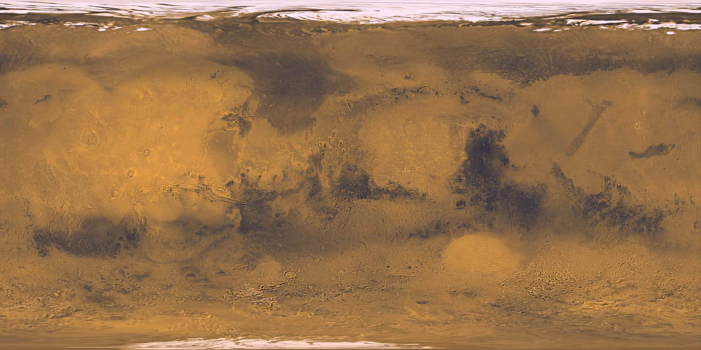 A Mercator Mars map in true color???.
For feature names refer to HI-185.
Zero longitude is in the center.
The large dark region in the eastern hemisphere is Syrtis Major which is the most prominent dark region seen from Earth and was first identified by Huygens in the 17th century.
Crater Schiaparelli is on the equator just east of zero longitude. This crater is named for Italian astronomer Giovanni Schiaparelli who determined in 1877 that the Martian canals were a major feature of Mars.
-
[Actually, in calling them canali in
Italian he was not implying that they were artificial: his meaning
was probably closer to the English channels
(Se-477--478).]
The western hemisphere can most easily be identified by spotting VALLES MARINERIS. West of Valles Marineris are three volcanoes in a row and to the west of that is Olympus Mons, the largest known volcano.
These volcanos are all in the THARSIS REGION or dome: this is a giant bulge that is, perhaps, above a giant mantle plume that has forced it up and given rise to the region's strong volcanism (HI-190--191).
The Tharsis dome may be something like coronas of Venus (HI-191).
The Hellas Planitia impact basin is at centered about 40 S, 70 E. It is low, circular region probably formed by a giant impactor similar to the ones that formed the Orientale Basin on the Moon and the Caloris Basin on Mercury???? (HI-199).
Note the southern hemisphere looks more heavily cratered than the northern hemisphere.
-
Question: If this map is accurate, what hemisphere
is experiencing winter?
- The northern hemisphere.
- The southern hemisphere.
- The eastern hemisphere.
- The western hemisphere.
Answer 1 is right.
-
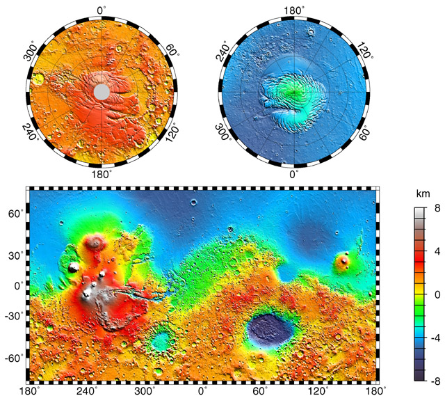 A Mercator topographical Mars map showing elevation.
For feature names refer to HI-185.
Note the southern hemisphere is generally higher than the northern hemisphere. The southern hemisphere is believed to be 2--4 Gyr and is ancient heavily cratered plains.
The northern hemisphere covered by younger lava flows, perhaps, on average 1 Gyr old (HI-189).
Note that the THARSIS REGION is the highest region on Mars.
HELLAS PLANITIA, a probable impact basin flooded by lava, is just about the lowest region at least at mid-latitudes (HI-185).
The ``wry smile'' of Valles Marineris is clear on the east side of the Tharsis dome.
Credit: NASA Goddard Space Flight Center, image #PIA02031; download site Views of the Solar System by Calvin J. Hamilton.
-
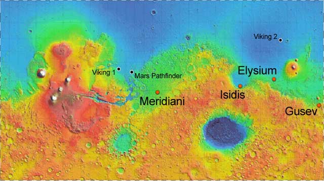 A Mercator topographical Mars map showing elevation and
lander sites through 2004.
A Mercator topographical Mars map showing elevation and
lander sites through 2004.
There have only been 5 successful landers on Mars through 2004:
- Viking 1, 1976jul20, Chyrse Planitia (HI-182--184).
- Viking 2, 1976sep03, Utopia Planitia (HI-182--184).
- Mars Pathfinder with rover Sojourner, 1997, near Chyrse Planitia (HI-183).
- Mars Exploration Rover Spirit, 2004jan04 UT, Gusev Crater ( NASA: Spirit Lands On Mars and Sends Postcards).
- Mars Exploration Rover Opportunity, 2004jan26 UT, Meridiani Planum ( NASA: NASA Hears From Opportunity Rover On Mars).
Credit: NASA/JPL.
-
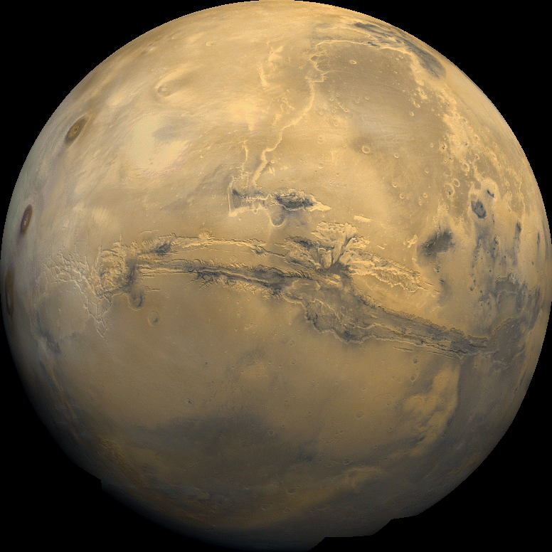 A Viking 1 Orbiter mosaic image of the western hemisphere of Mars.
1980feb22.
A Viking 1 Orbiter mosaic image of the western hemisphere of Mars.
1980feb22.
The ``wry smile'' at the center is Valles Marineris, the largest canyon on Mars. It extends about 5000 km (almost a quarter way around the equatorial region), is about 7 km deep, and is up to 100 km wide (FMW-198).
The two most northern of the Tharsis region triplet of volcanoes are visible to the west of Valles Marineris.
Some impact craters, channels, and dark regions can also be seen.
Credit: NASA.
-
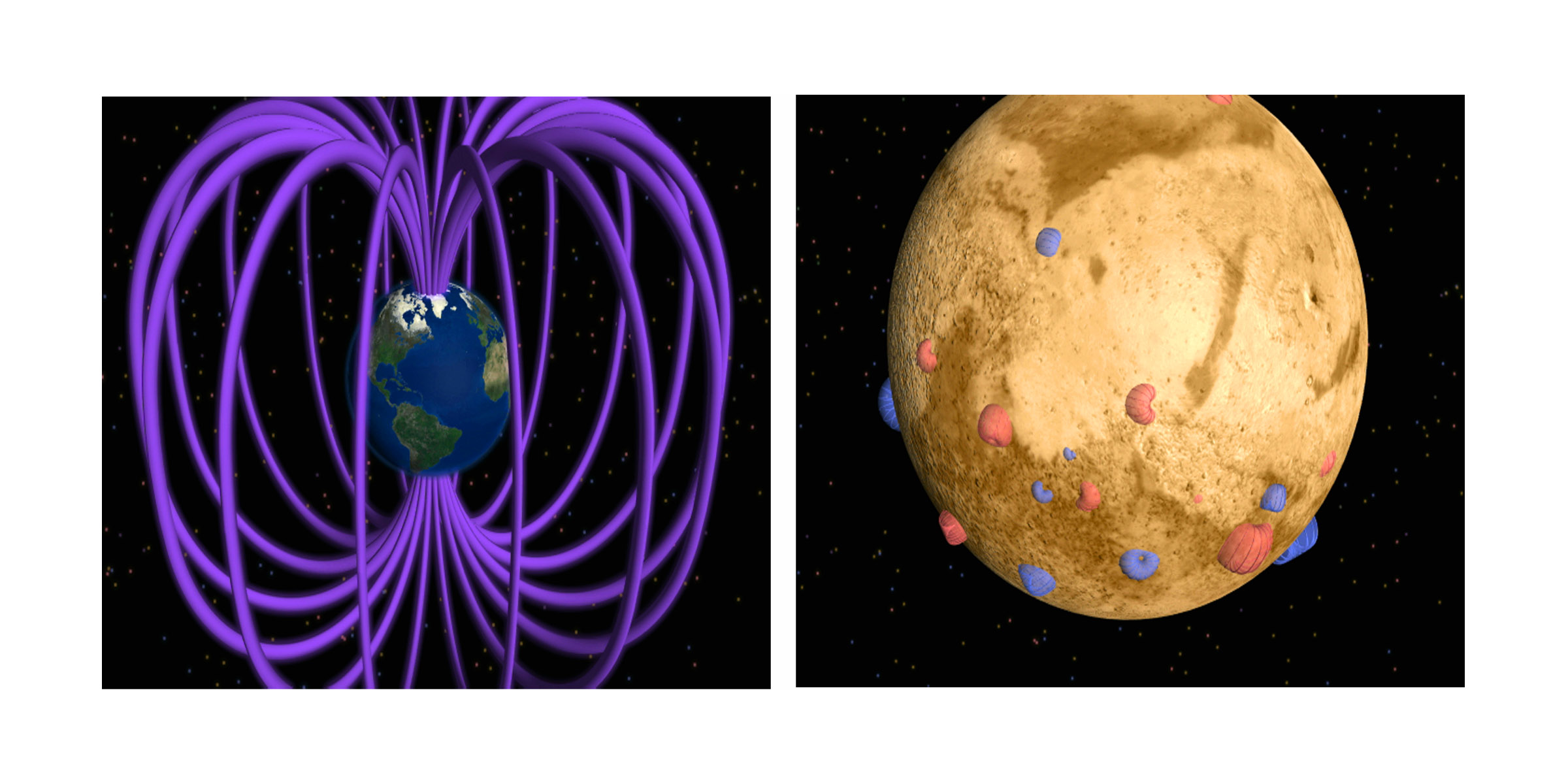 A cartoon comparing Earth's and Mars' magnetic fields.
Earth's magnetic field is a global dipole field like a bar magnetic. It is believed to be caused by a dynamo effect of conducting liquid iron in the Earth's iron core.
Mars' iron core may no longer be liquid even in part. In any case, it is not generating a global field. There are small local fields due to permanently magnetized rock????. These are fossil magnetic fields.
Credit: NASA, Mario Acuna, Jack Connerney, Chris Meaney download site Views of the Solar System by Calvin J. Hamilton. The images are public domain, but CJH declines to give a download source.
-
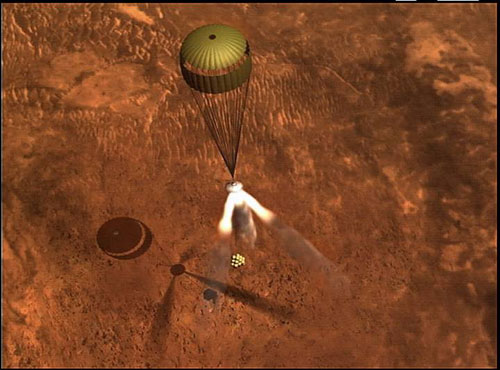 Parachute descent.
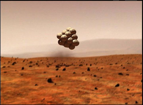 Bouncing on airbags
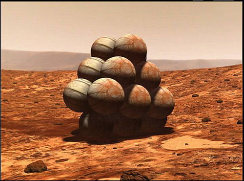 Airbag encased and at rest on Mars.
Artist conceptions of how the Mars Exploration Rovers of 2004 (Spirit and Opportunity) landed.
Credit: NASA/JPL.
-
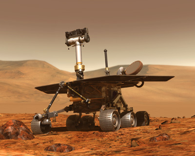 Mars Exploration Rover, artist conception, 2004.
Credit: NASA/JPL.
-
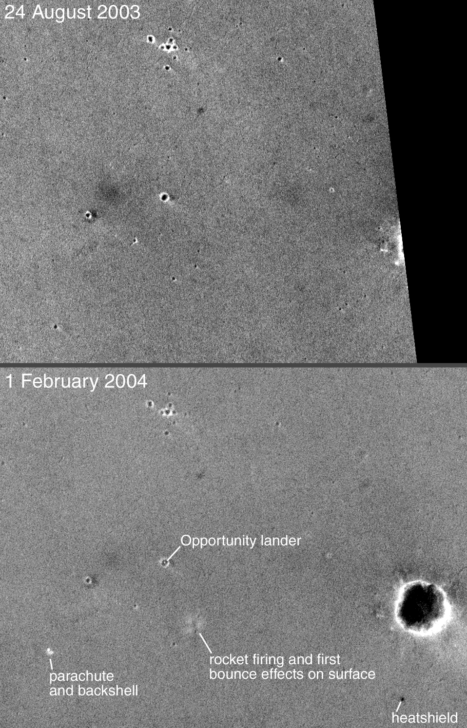 Mars Global Surveyor (MGS) Mars Orbiter Camera (MOC) images
of Opportunity landing site. 2003aug24, 2004feb01.
Mars Global Surveyor (MGS) Mars Orbiter Camera (MOC) images
of Opportunity landing site. 2003aug24, 2004feb01.
The Mars Exploration Rover Opportunity landed 2004jan25 on Meridiani Planum near 2.0 degrees S, 5.6 degrees W.
North is at the top, east is at the right, and the lower image is about 1.4 km wide.
Opportunity came to rest in a small crater of approximately 20 m in diameter.
Credit: NASA/Malin Space Science Systems.
-
 European Space Agency (ESA) Mars Express Orbiter. From 2003 on.
Mars Express has imaging and spectroscopic capability.
Credit: ESA 2001, Illustration by Medialab. ESA gives permission for educational use and reproduction.
-
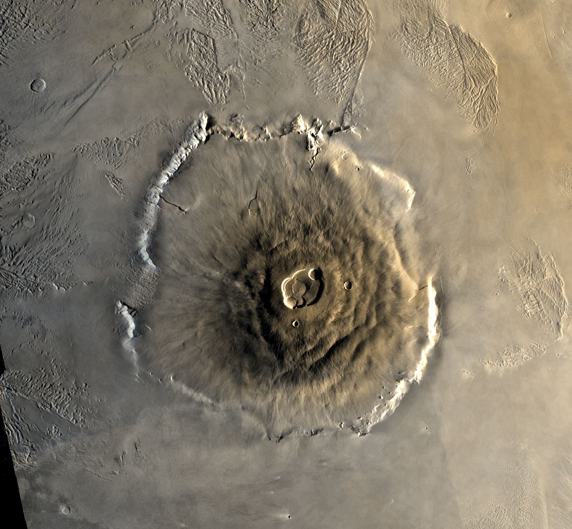 Olympus Mons in the Tharsis region of Mars.
This is an approximately true color mosaic image from Viking Orbiter 1 from 1978jun01.
Olympus Mons is the largest known volcano in the solar system.
It is a shield volcano with shallow slopes of 2 to 5 degree grade. You could walk up it.
The base is about 500 km across, the height above the lower deserts is 24 km, and the summit caldera is about 65 km across (HI-190).
Credit: NASA.
-
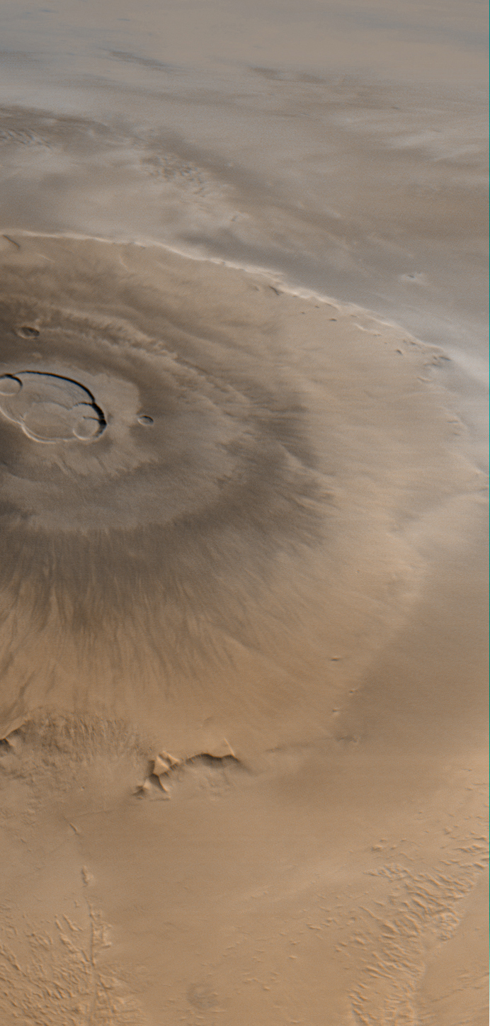 Olympus Mons in the Tharsis region of Mars.
This is Mars Orbital Camera (MOC) approximately true color image from 1998apr25.
Olympus Mons is the largest known volcano the solar system.
It is a shield volcano with shallow slopes of 2 to 5 degree grade. You could walk up it The base is about 500 km across, the height above the lower deserts is 24 km, and the summit caldera is about 65 km across (HI-190).
-
[Calderas on Earth anyway form when a chamber near the summit
is partially emptied by the outflow of lava and ash collapse
to form a broad flatish depression with steep walls
(SWT-573).]
The clouds are water ice clouds (such as we have on Earth) I think (FMW-200--201).
There are also dust clouds and CO_{2} clouds, but the former might look dustier and the latter are supposed to be high altitude whatever that means for Mars.
Anyway water ice clouds are supposed to often form near mountains.
Credit: NASA/Malin Space Science Systems; download site Views of the Solar System by Calvin J. Hamilton. The image is public domain, but CJH declines to give a download source.
-
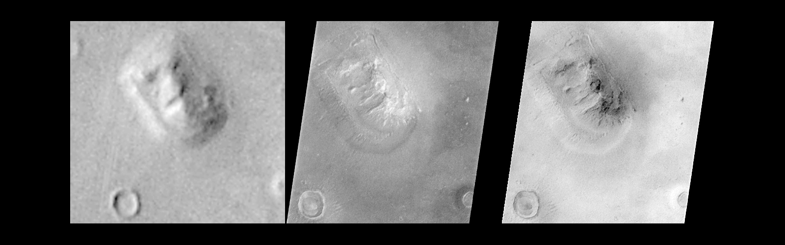 Infamous face on Mars debunked.
The image on the right is the best Viking Orbiter 1 image of the face which is not the one that made the headlines in the 1970's. It doesn't look that much like a face when you look at it closely.
The middle image is a higher resolution Mars Orbital Camera (MOC) image from 1998apr06.
The right image is the MOC image reprocessed to imitate the lighting conditions of the Viking image.
The face is seen to be a result of an odd hill, with particular shadows, and low resolution.
The face is at 40.8 N, 9.6 W which is nowhere in particular on Mars---well it's the Cydonia region---sort of the boondocks of Mars.
Credit: NASA/Malin Space Science Systems; download site Views of the Solar System by Calvin J. Hamilton. The image is public domain, but CJH declines to give a download source.
-
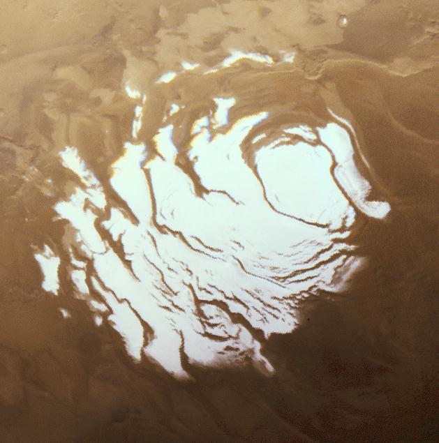 A Viking Orbiter image of the southern polar cap in the southern summer.
The cap is about 400 km across and this is about as small as it gets.
The northern polar cap has a larger residual size of 1000 km across (FMW-201).
Because it is mid-summer, the pole is in constant daylight with the night side of the planet here at the bottom of the picture.
The polar caps consist of water ice perhaps up to several kilometers thick covered by a layer of CO_2 ice that may be centimeters to several meters in thickness (HI-188).
Both kinds of ice tend to be white when they have a rough surface.
The water ice never evaporates much, but much of the CO_2 ice evaporates with the summer and condenses again in the winter.
-
[Actually, ``sublime'' is the specific technical term for a solid to
gas phase transition.]
Credit: NASA; download site Views of the Solar System by Calvin J. Hamilton. The image is public domain, but CJH declines to give a download source.
-
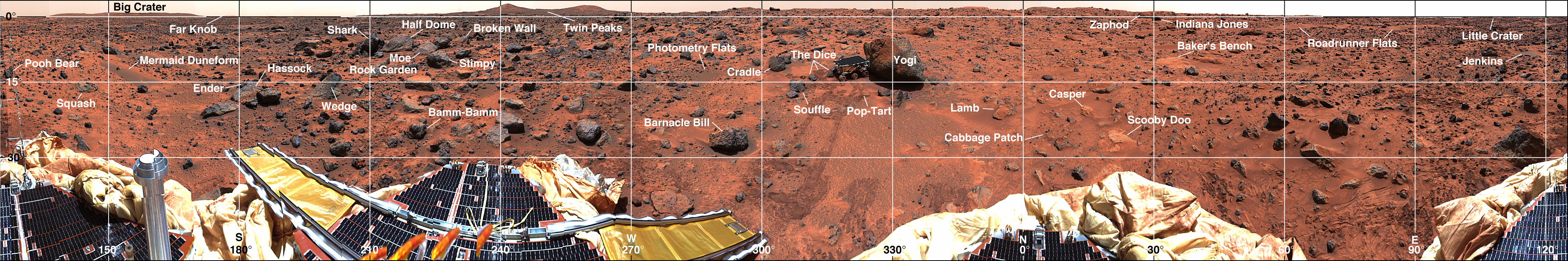
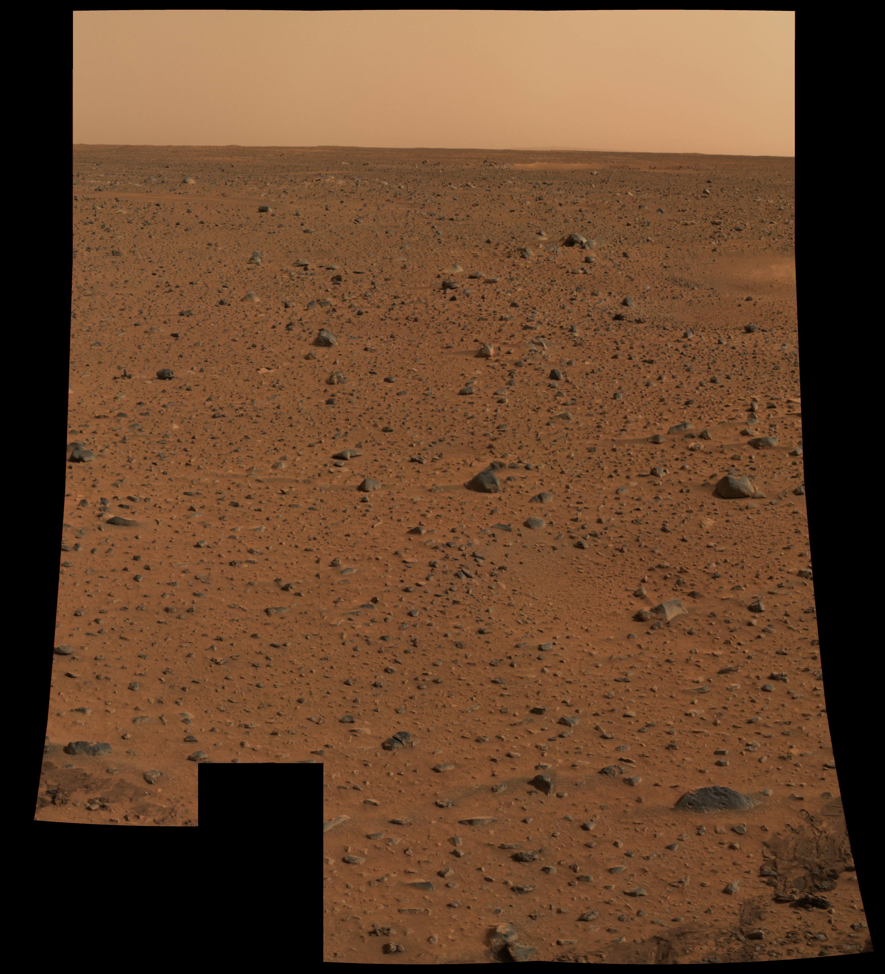
The terrain around the Pathfinder landing site. 1997dec.
Pathfinder was the first lander since the Viking 1 and 2 landers in the 1976. It landed in 1997 (a href="../../writer/ref.html#hartmann">HI-183--184).
The image is a 360 degree panorama.
In order to study the surroundings in detail with the SOJOURNER ROVER (near Yogi at 320 degrees in the image), it was necessary to map the landscape.
For mnemonic reasons names were given to quite small features: names were evidently derived from a variety of pop-cultural sources.
As one can see the sand is reddish and so are some of the rocks. The red color is due to iron oxide and is typical of Mars (PF-118).
Mars is the Red Planet after all.
Credit: NASA/USGS; download site Views of the Solar System by Calvin J. Hamilton. The image is public domain, but CJH declines to give a download source.
-
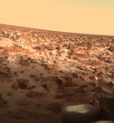 The terrain around the Viking 2 Lander site. 1979may18.
The Viking 2 Lander was in the northern/eastern hemisphere Utopia Planitia lava plain. It landed 1976sep03 (HI-184), and so must have operated a long time.
The time of the image is the northern winter???.
The image is true color. The red rock and dust is due to iron oxide (and rust) mineral content.
Whitish covering is CO_2 frost. It is thought that dust grains covered with a bit of ice serve as condensation sites for CO_2.
When it gets cold enough (below 150 K: FMW-201), the CO_2 condenses out on the grains and the grains fall to the ground.
Credit: NASA: image #P-21873.
-
 The projected landing site of the Beagle 2 lander.
The European Space Agency's (ESA') Mars Express probe sent down the Beagle 2 lander to land on Isidis Planitia (11.6 N, 90.75 E) on 2003dec25.
The Beagle 2 lander was specifically designed to test for life signs.
Alas it went down on Mars and was never heard from again: this is the fate of many landers.
It could not, of course, directly test for the Martian deep biosphere, but it can test a likely place on the surface for signs of life. Perhaps micro-fossils or biological compounds were to be looked for.
The landing site seems to be a sedimentary basin and thus date from an epoch of surface water.
The ellipses on the image presumably mark out the landing target area.
Note the half-seen crater. The impact apron around it seems at bit thick to me.
It may be one of those aprons that is interpreted as having been made out thick slurry of material from an impact on ice-laden soil (HI-190). But I don't really know. See ESA Beagle 2 site and The University of Leicester Space Research Centre's Beagle 2 site).
Credit: NASA.
-
 Color panorama of Gusev Crater. Spirit, 2004jan06.
An early color panorama from the Spirit rover.
The lower right shows where the soil was disturbed by the lander's airbags.
-
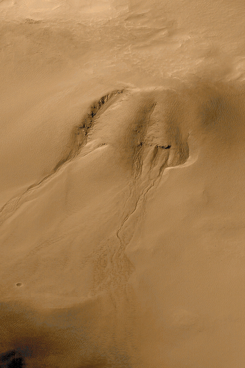 An approximately true color image of a Martian gully.
The MOC image is from 1999sep28. The image is 9 x 6.7 km. We are viewing the south-facing inner rim of the crater. There is a sand dune on the crater floor. The location is 54.8 S, 342.5 W (or 17.5 E).
The gullies are eroded into the rim of impact Crater Noachis Terra. The image is an approximate true color, high resolution image from the Mars Global Surveyor's Mars Orbiter Camera (MOC).
One sees the channels and apron of debris. It seems that there must have been groundwater seepage and surface runoff leading to the apron.
The feature is very similar to gullies seen in the American south-west.
There are no superimposed craters indicating that the gullies are geologically young. How young?
-
[There is one little crater it seems near the bottom left,
but it isn't superimposed ont apron of sediment.]
There may be liquid water in the Martian subsurface today.
Other images suggest water seepage within tens of years which is the same as saying it is ongoing ( Views of the Solar System by Calvin J. Hamilton.
Mars' atmosphere is too rarefied to allow liquid water to exist in THERMODYNAMIC EQUILIBRIUM. Only the solid and gas phases of water can persist.
Perhaps the liquid water in the subsurface is sometimes squeezed to the surface by a sudden geothermal event or an impact could melt ice near the surface.
If something like that happen, water could flow for awhile until it evaporated or froze.
Credit: NASA/JPL/Malin Space Science Systems. An alternative download site is Views of the Solar System by Calvin J. Hamilton. The image is public domain, but CJH declines to give a download source.
-
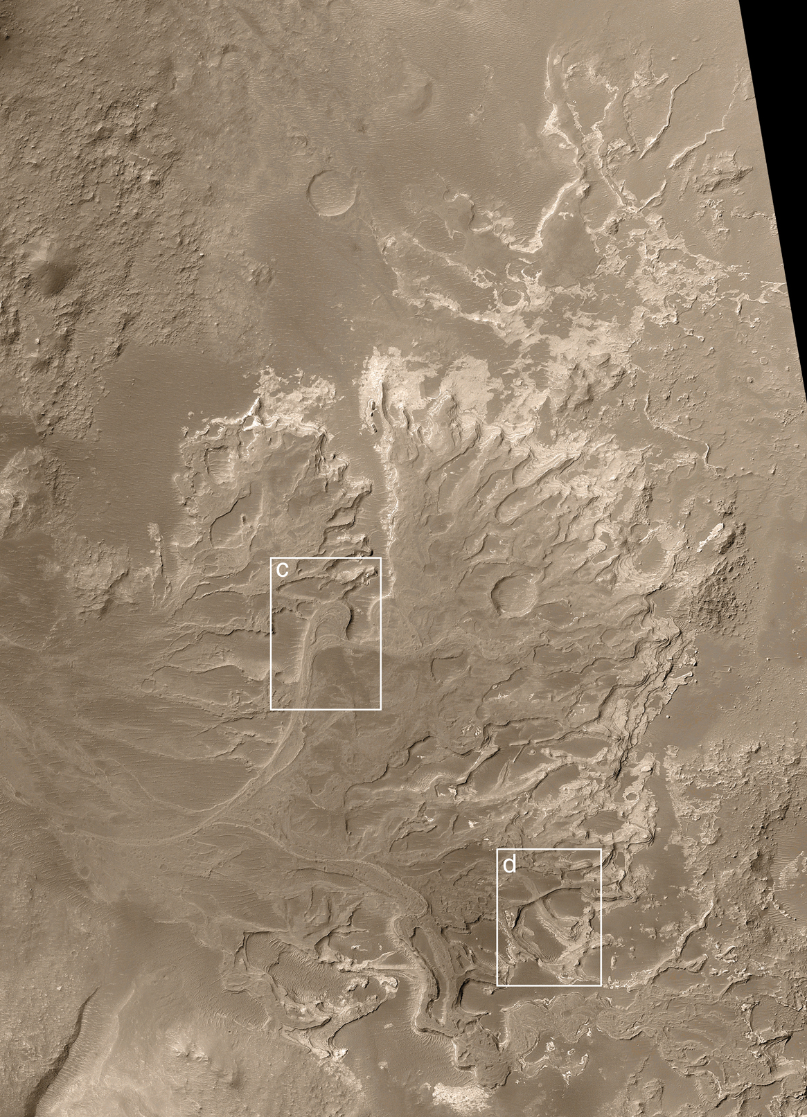 A distributary fan on Mars. From Mars Global Surveyor
Mars Orbiter Camera (MOC), 2003nov13. Image MOC2-543a.
A distributary fan on Mars. From Mars Global Surveyor
Mars Orbiter Camera (MOC), 2003nov13. Image MOC2-543a.
The fan is 24.3 S, 33.5 W. The image is 14 x 19.3 km. The fan is located in a partially destroyed impact crater of diameter 64 km.
A distributary fan is a river delta or similar alluvial feature.
The fan is important for 3 reasons:
- It proves there was persistent water flow on Mars.
Water channels have been long identified on Mars, but they it is argued that they could be due to flood events due sudden heating of frozen water: volcanic or impact heat would be the cause.
But to form a fan with typical fan features like oxbows (see below) takes time.
- The fan is marked out by sedimentary rock. The fan channels
are now raised above the surroundings. The sedimentary rock
must have been cemented harder than the surroundings.
Probably wind erosion has worn away the surroundings.
- It seems likely that the fan flowed into a body of water:
perhaps a small lake.
- Box c shows an oxbow is a loop in a meandering river typical
of the Mississippi River for example.
A cut-off meander has pinched off the oxbow: this is typical of meandering Earth rivers and requires persistent flow.
Note the impact crater to the east of box c. This crater is superimposed on the fan and so came later.
- Box d shows crossed channels with one clearly lower than the
other. This indicates the fan persisted long enough to reform
and cut new channels.
Clearly, Mars didn't have a lot of water channels and lakes or else the evidence has been destroyed by long ago volcanism and cratering.
Credit: NASA/JPL/Malin Space Science Systems.
- It proves there was persistent water flow on Mars.
-
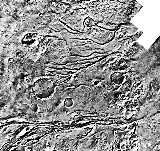 A network of channels on Mars.
This is a Viking Orbiter image showing a region just west of the Viking 1 Lander site in Chryse Planitia. Probably the coordinates are about 25 N, 50 W.
The image is about 300 x 300 km.
The network of channels strongly suggests rainfall and run-off: i.e., they could be RUN-OFF CHANNELS.
But they could have been formed by SAPPING.
In sapping, liquid ground water eats away at a cliff face. One images the water as frozen until some geothermal event temporarily melts it and this leads to sapping.
Whether or not this network is due to run-off I don't know.
In fact, the current thinking is that the some channels are Mars do indicate some persistent flow and rain.
But rain and run-off rivers were probably very intermittent.
It has been suggested that major impacts may somehow ??? have heated Mars for a few decades every few million years and thus brought about an intermittent wet Mars (publicized by Kerr, R. A., 2003jun06, Science, 300, 1496).
On the other hand, periods of intense volcanism may have temporarily given Mars a thickish CO_2 atmosphere that in turn gave Mars' enough greenhouse effect for liquid surface water and rain (HI-194).
Current thinking is that Mars was always too cold to be continuously wet.
But the story could change again---it keeps doing that you know.
Credit: NASA.
-
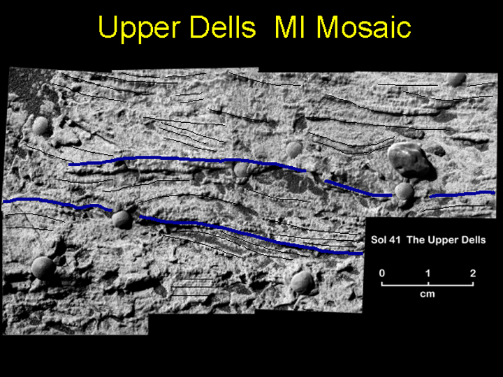 A view of a cross-laminated, sedimentary rock. Opportunity, 2004mar05.
The fine layers (laminae) in this rock are ``truncated, discordant and at angles to each other.''
I assume that these layers are the cross-laminae and there appearance means the rock is cross-lamination.
The BLACK LINES trace the cross-lamination and the BLUE LINES possible boundaries between sets of cross-laminae. Possibly the sets were laid down at different times???.
Cross-lamination indicates that these sediments were laid down by flowing water. The water flow was perpendicular to the plane of the image either inward or outward.
The water was 5 cm deep or so or much deeper and the flow speed was about 10 to 50 cm/s.
Chlorine and bromine in the rock suggests that the sediments were laid down in salty water where the concentrations of salts exceeded the saturation due to evaporation.
The formation enviromment may have been a sea shore or desert basin.
Credit: NASA/JPL/Cornell/USGS. See also the full press release NASA: Standing Body of Water Left Its Mark in Mars Rocks.
-
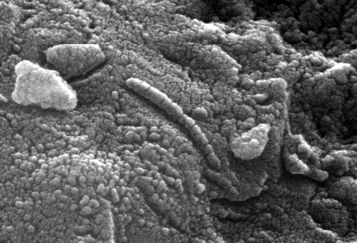 A microscopic image of the interior of meteorite Allan Hills 84001.
Allan Hills 84001 is meteorite found in Antarctica. It impacted about 13,000 years ago and left Mars about 16 Myr ago when an impactor knocked into space (Se-589).
Analysis of gas bubbles inside confirm that it is a Mars rock.
The rock itself is very old and formed about 4.5 Gyr ago (HI-196).
An analysis by NASA scientists in 1996 suggested that this meteorite contained fossils of microscopic Martian life that entered it long after formation.
They suggested elongated structure in this picture was Martian microbe.
To say the least this suggestion has been controversial. There has been a lot of back and forth and it seems no unanimous answer has been reached.
But I think the majority view is strongly against the structures being fossilized life.
Credit: NASA; download site On the Question of the Mars Meteorite at the Lunar and Planetary Institute site.
- The Martian Moons: Phobos and Deimos
-
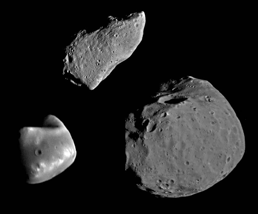 A comparison of Phobos (right), Deimos (left),
and asteroid 951 Gaspra (top)
A comparison of Phobos (right), Deimos (left),
and asteroid 951 Gaspra (top)
Table of properties of Mars' moons:
________________________________________________________________________

Body       Sidereal      Radius          Mass              Mean Distance
           Revolution    (km)            (Mars masses)     (Mars radii)
           Period
           (days)
________________________________________________________________________

Phobos    0.31891023 S   13.4x11.2x9.2   1.654*10**(-8)    2.761

Deimos    1.2624407  S   7.5x6.1x5.2     3.71*10**(-9)     6.9058

________________________________________________________________________
Source: Cox-302--307.
The ``S'' means that Phobos and Deimos have their revolution and rotation periods synchronized by tidal locking to Mars.
They both have prograde orbits, but Phobos' orbital period is shorter than Mars rotational period, and so Phobos rises west and sets east (Se-490).
The moons have low density (less than about 2 g/cm**3: Ab-14-4) and have rather dark colors. They may be very carbon-rich material---carbon in graphite form has density 2.3 g/cm**3---like carbonaceous chondrite meteorites (HI-197), and so may be very primitive material.
They are heavily cratered as one would expect for rocky, airless bodies.
Almost certainly Phobos and Deimos are captured asteroids perhaps close to the solar system formation epoch (HI-197).
They have such low gravity that rocks and dust are only weakly held and could easily be ejected into escape velocities when the moons are impacted.
It would certainly be interesting to study them in more detail.
-
Historical Note
Phobos and Deimos were discovered by Asaph Hall (1829--1907) in 1877 during a perihelion oposition ????: the same one in which Giovanni Schiaparelli concluded that the canals of Mars were a major real feature (HI-197, (FMW-186). He named the moons after the chariot horses of Mars: Phobos (fear) and Deimos (terror). The largest crater (diameter 8 km) on Phobos is named for Mrs. Hall nee Stickney. This crater is not seen in the image
As a historical oddity, Kepler predicted that Mars would have two moons based on the idea of completing the sequence???: Earth has 1 moon, Mars should have 2 moons, and Jupiter has 4 moons (as thought in circa 1610) (Ca-200). Of course, it is just an accident that this prediction turned out to be correct.
Phobos and Deimos have also figured in science fiction: e.g., Donald Wolheim's Secret of the Martian Moons: a somewhat mediocre opus that is noteworthy only in that it marks a very early phase in yours truly's long-lapsed career as a reader of scifi.
-
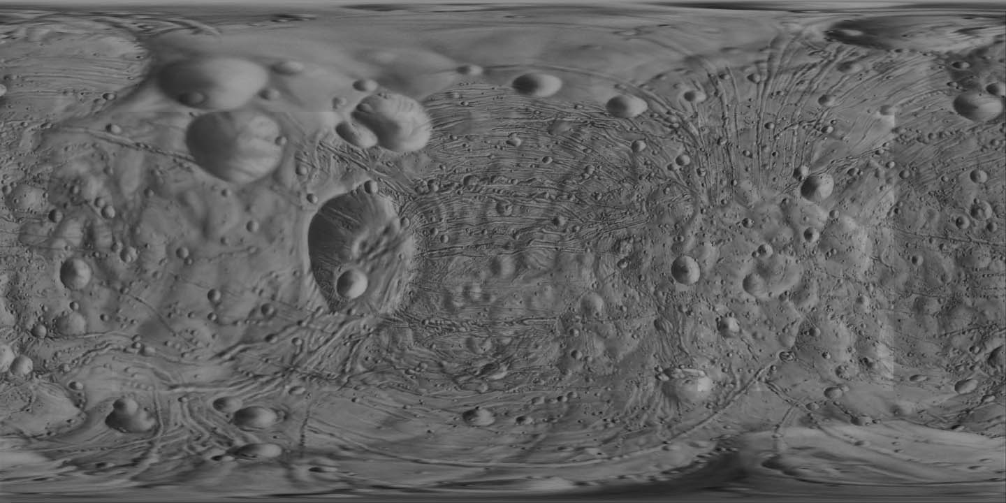 A ``Mercator'' map of Phobos based on Viking images.
Since Phobos isn't spherical this is not a true Mercator projection. But somehow USGS has unwrapped the moon.
Crater Stickney is the biggest crater: diameter about 8 km.
Credit: NASA/USGS; download site Views of the Solar System by Calvin J. Hamilton. The image is public domain, but CJH declines to give a download source.
-
 A Viking image of Phobos.
Crater Stickney (about 8 km in diameter) is prominent. The impact that created Stickney may have nearly shattered Phobos. The impact may to have caused the parallel grooves that emanate from Stickney: the grooves presumably are some kind of fracture (Se-490).
Credit: NASA; download site Views of the Solar System: Mars by Calvin J. Hamilton. The images is public domain, but CJH declines to give a download source.
-
 A Viking image of Deimos
Deimos is smaller than Phobos and has a smoother appearance. The smoother appearance is probably just a heavy coating of dust (Se-491). Presumbably, the heavy dust coat reflects a different history of impactors.
Credit: NASA; download site Views of the Solar System by Calvin J. Hamilton. The image is public domain, but CJH declines to give a download source.
-